


From Glacier to Wine Hiking Trail
The most beautiful hiking trail through Steiermark
The tour from the eternal ice of the Dachstein to Styria's wine region makes every outdoor lover’s heart beat faster. Impressive mountains, unspoilt nature reserves, venerable culture, heavenly spas and regional delicacies: Discover all of this and more along the northern and southern route of the new long-distance hiking trail!
From Glacier to Wine – on two routes
Long-distance hiking in Styria
As they say, the journey is the reward. This is especially true for the picturesque “From Glacier to Wine” hiking trail. The surrounding landscapes are among the most varied stretches of nature in Europe. What’s more, plenty of culinary and cultural highlights are waiting along the way.
What is the hiking route "From glacier to wine"?
- It starts at the Dachstein glacier and thus at the foot of the majestic Dachstein with its 2,995 meters.
- It offers scenic diversity in a density that is unparalleled anywhere in Europe.
- It represents the hiking offer of Styria in its entire exciting range.
- It offers multifaceted opportunities to discover Styria, its people and culture.
- It leads through different areas with their huts in the alpine north and wine taverns in the lovely south - so every nature enthusiast finds his way on partial sections with stages of 3-8 days.
- It is marked with thousands of stickers on the existing signage of the alpine associations, and thus shows the way across Styria.
The first stage leads through the eternal ice to the Guttenberghaus above Ramsau am Dachstein. Here, the trail splits in the direction of Weinland and long-distance hikers can choose between the northern route, which leads to Bad Radkersburg in the Thermen- & Vulkanland over 35 days. And the southern route, which ends after 25 daily stages in Leibnitz in the Nature Park Südsteiermark.
On the Dachstein-glacier | © Steiermark Tourismus | pixelmaker.at
1/12
At the Ahornsee lake | © Steiermark Tourismus | pixelmaker.at
2/12
In the Notgasse | © Steiermark Tourismus | pixelmaker.at
3/12
Wörschachklamm gorge | © Steiermark Tourismus | pixelmaker.at
4/12

Lärchbodenalm in Ramsau am Dachstein | © Steiermark Tourismus | Martina Traisch
5/12
View of the Erzberg from the layer tower in Eisenerz | © Steiermark Tourismus | pixelmaker.at
6/12
View to Mürzzuschlag | © Steiermark Tourismus | pixelmaker.at
7/12

Sackwiesensee lake in the Hochschwab area | © Steiermark Tourismus | Michael Weberberger
8/12
View from Pöllauberg into the Pöllauer Tal Nature Park | © Steiermark Tourismus | pixelmaker.at
9/12
Lookout ruin Klöch | © Steiermark Tourismus | pixelmaker.at
10/12

Castle Deutschlandsberg | © Steiermark Tourismus | Martina Traisch
11/12

Vineyard Bullmann, Ratsch an der Weinstraße, Southern Styria | © Steiermark Tourismus | Atelier Jungwirth / allOver
12/12
A trail of culinary delights
Varied hiking experiences in Styria
Styria boasts great variety – both in its landscapes and in its culinary delights. Styria is a paradise for food and nature lovers alike, especially along the “From Glacier to Wine” hiking trail. Whether it’s at the numerous mountain huts or wine taverns along the northern or southern route or at one of the many “Kulinarium Steiermark” partners: The trail is dotted with opportunities to sample regional specialities.
Good to know: Of course, you can also pick individual stages of both routes. The well-developed public transport network of trains and buses plus numerous hiking shuttle busses and taxis make it easy to get to and from almost any access point along the way.
About 1,000 kilometres of hiking happiness: Tour variations such as an alpine stage in the Gesäuse region or the use of cable cars give you access to a total of 995 kilometres of hiking trails.
The northern and southern routes at a glance
Quick facts
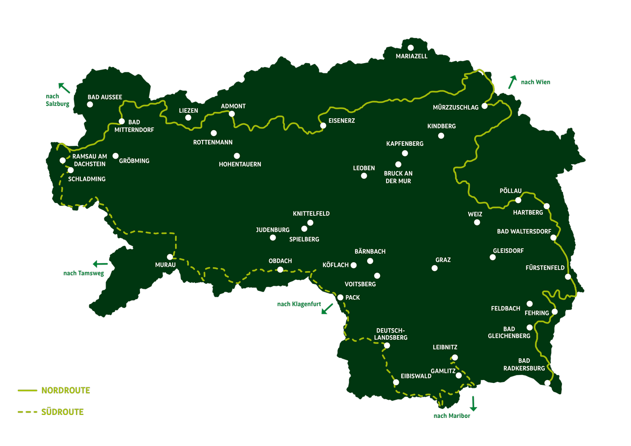
The northern route
- starts at: Dachstein
- ends at: Bad Radkersburg
- distance: 524 km
- stages: 35
The southern route
- starts at: Dachstein
- ends at: Leibnitz
- distance: 370 km
- stages: 25
The northern route
From the snow-capped mountains of the Dachstein and the Rax to the gentle hills of the wine region with its marvellous orchards and spas. The 35 day stages of the northern route bring you up close to Styria’s impressive natural contrasts of rugged peaks, shady forests, alpine vastness and rustic charm.
In the alpine north, you can find the craggy limestone mountains between the Dachstein, the Gesäuse region, the Hochschwab and the Rax. In the green mountains of the Fischbach Alps, Upper Styria’s imposing mountain world meets the pleasurable, charming orchards of Eastern Styria. What’s more, the route also takes you past Almenland Nature Park, Europe’s largest connected low alpine pasture area, and Pöllauer Tal Nature Park.
The Styrian Spa Country boasts six inviting spas between Bad Waltersdorf, Bad Blumau and Bad Radkersburg. In this area, you can also find fascinating manufactories like those of Alois Gölles or Josef Zotter as well as cultural highlights such as Riegersburg castle.
By the way: If you would like to find out more about the region Hochsteiermark, we recommend embarking on the “BergZeitReise”, encompassing stages between Hochschwab and Fischbach Alps along the northern route.
Stages of the northern route
All tour variants at a glance

The southern route
The 25 day stages of the southern route take you from the Dachstein to the Schladming Tauern and the mountaineering village of Krakau. Along the way, you will visit the historic city of Murau and Zirbitzkogel-Grebenzen Nature Park. Your long-distance hiking experience is topped off by the culinary delights found in the Schilcherland region and Southern Styria Nature Park.
The snowy peaks of the Dachstein mountain range give way to the crystal-clear mountain lakes, lush green alpine pastures and Ice Age scree fields of the Schladminger Tauern. In addition to the Old Town of Murau, the Benedictine Abbey of St. Lambrecht and Zirbitzkogel scenic mountain are well worth a visit in Zirbitzkogel-Grebenzen Nature Park.
Next up is the Zirbenland region with Obdach village and the Packalpe and Koralpe, a long mountain ridge that runs along the border between the provinces of Styria and Carinthia and leads up to the wine region. From there, the landscape is dotted with picturesque vineyards and rustic wine taverns that invite long-distance hikers to take a break on their way through the Schilcherland region and onwards to Leibnitz and Southern Styria Nature Park.
Stages of the southern route
All tour variants at a glance


 at the Putzentalalm | © Steiermark Tourismus | Tom Lamm")


Helpful informations
Frequently Asked Questions - FAQ
What is the best way to make reservations with the cabins? And which equipment should you take with you?
In order to be well prepared on your hiking route “From the Glacier to the Wine”, we answer your frequently asked questions.
Trails in the alpine area often require surefootedness and a head for heights - please bear this in mind when planning your tour. Good and precise planning provides safety and ensures more enjoyment during your holiday. Please take note of the available stage descriptions - including altitude profiles. If necessary, you can obtain information from alpine associations and local experts, such as cabin owners. If you are travelling in a group, please adapt your pace to the weakest members. And please do not leave the marked trail for your own protection and out of consideration for nature and wildlife.
You should book in advance, if:
- you need accommodation during peak season or on weekends
- you value a certain standard of furnishings and equipment
- you want to book accommodation in the immediate vicinity or on the hiking route
- you are travelling with several people
The tourist offices along both routes will be happy to help you find accommodation. Otherwise, it is sufficient to book by telephone the day before you arrive. However, if the hut is fully booked, the cabin owners and the tourist offices will be happy to help you find an alternative.
The northern and southern routes are in their entirety only accessible from June to the beginning of October. Before June, one must expect residual snow between the Dachstein and Stoderzinken, in the Gesäuse, on the Hochschwab and in the Schladminger Tauern. We therefore recommend the stages and sections in the two areas of Eastern Styria to Spa and Volcano Country and Schilcherland to Southern Styria for hikes in spring and late autumn. Numerous passionate long-distance hikers also like to use these route sections in spring to "warm up" for the main hiking season.
Numerous bus lines or collective or hiking taxis as well as several train lines are available along the entire route. That way, you can return to your respective starting point. Please also note the numerous hiking- and valley-bus offers along both tours. Often, these are available at greatly reduced rates or even free of charge in conjunction with a regional all-inclusive card, as in the Schladming-Dachstein holiday region, Eastern Styria and Spa and Volcano Country. For more information, please contact the respective tourist region.
1. Always adapt your equipment to the undertaking and make sure your backpack is light. Below, you will find recommendations for your journey of discovery along the hiking route “From the Glacier to the Wine". When it comes to clothing, breathable outdoor clothing that is suitable for all weather conditions is important. Likewise, please do not forget sunscreen & co:
- Sun protection (sunglasses, sun cream and lip protection, cap)
- Rain protection (poncho, peaked back, backpack protector)
- Jacket
- Protection against the cold (hat, gloves)
- Backpack with padded straps and ventilated back
- Jacket
- T-shirts, short and long sleeve
- Underwear
- Hiking trousers
- Hiking boots with non-slip profile soles
- Hiking socks
- Hiking poles (telescopic poles are ideal)
- Water bottle
What else should be in your backpack
- Identity card, insurance and membership cards (e.g. Alpine Club)
- Cash (as it is not possible to pay with ATM or with credit card at most cabins)
- First aid kit and personal medication (blister plasters, vitamin/magnesium tablets, etc.)
- Camera incl. batteries/replacement batteries, binoculars
- Mobile phone with full battery and charger (important phone numbers)
- Plastic bag for rubbish and/or dirty laundry
- Headlamp/small torch
- Pocket knife and lighter
- Toilet paper
- Tour book/diary incl. pen/pencil, playing cards, etc.
- Overnight utensils (cabin sleeping bag, toilet articles, comfortable shoes and clothes, towel, etc.)
- Hiking map and information material, GPS optional
Please always pack enough food (check availability at the respective stage location). Muesli bars, nuts or dried fruit, for example, are a good in-between snack. And: Don't forget to bring enough to drink!
There are numerous camping and caravan sites along both routes - we have collected the most beautiful sites for you. Due to the good rail and bus connections along the route, you can also use them as a base and return in the evening after the hike. As in many European countries, "wild camping" is generally prohibited in Austria. The law states that camping is permitted in the wasteland, i.e. above the forest line. However, there are countless exceptions here. You are best advised to plan your tour well and make use of the network of cabins and campsites.
The main thing about hiking with children is that the little ones are able to discover nature through playing. In principle, children have the most fun, when other kids of the same age are along for the tour. Whether the sections of the route are suitable for your youngsters depends on their age and physical condition. Children who have already gained mountain experience can do the entire hiking route. Please also note that the lengths of the daily stages usually have to be shorter than the classic stage division when children are with you. In any case, you can also get support in planning from the respective local tourism association.
Generally, yes. We recommend registering your dog in advance at your respective accommodation. Dogs are welcome in many, but not all accommodations.
Please note that dogs are perceived as potential enemies by cattle, and especially by mother cows. The following behavioural measures ensure the safety of both people and dogs: Always keep your dog on a leash and take it into the middle of the group if possible. Please ensure that the dog behaves calmly, is kept on a lead and has a muzzle, as there are also children on the paths. If an attack by cattle is unavoidable, you should definitely let the dog off the leash immediately for both of your protection. This way, the dog is the target of the attack and the danger is averted from you. Dogs are usually quick enough to escape an attack by a cow. Please never pick up a dog and try to defend it against the cattle.
Please send an email to info@steiermark.com. Here, you can tell us exactly where you have noticed deficiencies and what needs to be improved. The information office of Styria Tourism will be happy to forward this to the relevant section of the Alpine clubs and tourism associations.
")


