


Gamskögel west summit
Characteristics
SkillThe tour in numbers
Level of difficulty
medium
Route
10,8 km
Time
6:00 h
Uphill
960 hm
Downhill
960 hm
Highest point
2386 m
“The Animal": This varied tour to the Gamskogel (2,386 m) starts in the Bärental valley and leads via the Gaaler Törl to the summit region. Climbing steeply with impressive views, you reach the summit cross after around three hours. The north side impresses with steep cliffs, while to the south the panorama stretches as far as the Zirbitzkogel.
The hike to the Gamskogel (2,386 m) begins in the Bärental valley and leads steadily uphill along a forest path. The forest path ends at around 1,750 m, from where you follow the climbing tracks and markings to the Gaaler Törl (2,081 m). After a steep passage, you reach the summit either via the Hochleitenspitze or a bypass. The view extends from the Zirbitzkogel to the Seckauer Tauern, while the steep north face is impressive. The descent follows the same route. A challenging but rewarding tour with magnificent panoramic views and alpine character.
Best season
January
March
March
April
May
June
July
August
September
October
November
December
More information
From Möderbrugg, drive into the village of St. Johann am Tauern. After the former Gasthaus Bruckenhauser inn, turn right into the Bärental valley. Past the Franzlbauerhütte to the Bärntal parking lot.
You can park your car at the Bärntal parking lot.
You can park your car at the Bärntal parking lot.
From the parking lot shortly after the Franzlbauernhütte in Bärental, we follow the markings in the direction of Gamskogel and continue along a forest path. After approx. 30 minutes and 200 meters in altitude, the trail continues uphill on a forest path, shortly afterwards you meet the forest path again, which ends at approx. 1,750 m above sea level. From here, follow the clear climbing tracks and red and white markings to the Gaaler Törl at 2,081 m above sea level. Once there, the surrounding mountains are already quite clearly visible and an icy wind often whips you in the face.
Then continue left towards Hochleitenspitze, which can be reached in 45 minutes according to the signposts. The path becomes steeper and steeper and so you quickly make up a lot of altitude and soon reach the neighboring summit of our destination, the Hochleitenspitze. However, this can also be bypassed below on well-trodden paths. After 2 ½ to 3 hours of walking, you are standing on the Gamskogel and (hopefully) enjoying the sunshine and the view. The north side of the Gamskogel is particularly impressive, as the mountain drops almost vertically here; this ascent variant from the Triebental valley is particularly popular with climbers. To the south, the Zirbitzkogel can be seen in the distance, while the Lahneck, Glaneck, Kesseleck and Amachkogel and its western neighbor, the Lärchkogel, are much more prominent. The way back follows the same route.
Then continue left towards Hochleitenspitze, which can be reached in 45 minutes according to the signposts. The path becomes steeper and steeper and so you quickly make up a lot of altitude and soon reach the neighboring summit of our destination, the Hochleitenspitze. However, this can also be bypassed below on well-trodden paths. After 2 ½ to 3 hours of walking, you are standing on the Gamskogel and (hopefully) enjoying the sunshine and the view. The north side of the Gamskogel is particularly impressive, as the mountain drops almost vertically here; this ascent variant from the Triebental valley is particularly popular with climbers. To the south, the Zirbitzkogel can be seen in the distance, while the Lahneck, Glaneck, Kesseleck and Amachkogel and its western neighbor, the Lärchkogel, are much more prominent. The way back follows the same route.
Basic rules for hikers in the Pölstal...
Check your personal condition before every mountain tour and estimate your strength correctly. The length of your tour will depend on this. Plan each tour carefully. Pay close attention to the necessary equipment, make sure you have enough provisions and check the local weather forecast. Inform acquaintances about your hiking destination, as well as the planned return time, if necessary. Always stay on the marked trails. Always close fences and pasture gates. Watch out for falling rocks and do not kick any rocks yourself. Doing so will endanger other hikers. In case of bad weather, sudden indisposition or other difficulties, do not take risks and turn back in time. Avoid approaching wild animals. - Observe from a distance. Keep dogs on a leash. Use designated parking areas, please do not block access roads, and observe local driving restrictions.
What do I need when hiking?The equipment is depending on the difficulty, location and duration of the hiking route,
as well as according to your own needs:
- sturdy shoes
- backpack
- clothes suitable for the season
- sun protection (glasses, headgear, cream)
- small first-aid kit (gauze bandage, plaster, scissors and knife)
- orientation aids (hiking maps)
- sufficient drinks and provisions
- cell phone with emergency numbers
personal medication
Enjoy the wonderful tour!
This tour is NOT considered "accessible by train and bus" because there is no regular connection.
More information at www.murtal.at/wandern
Map & downloads
Gallery
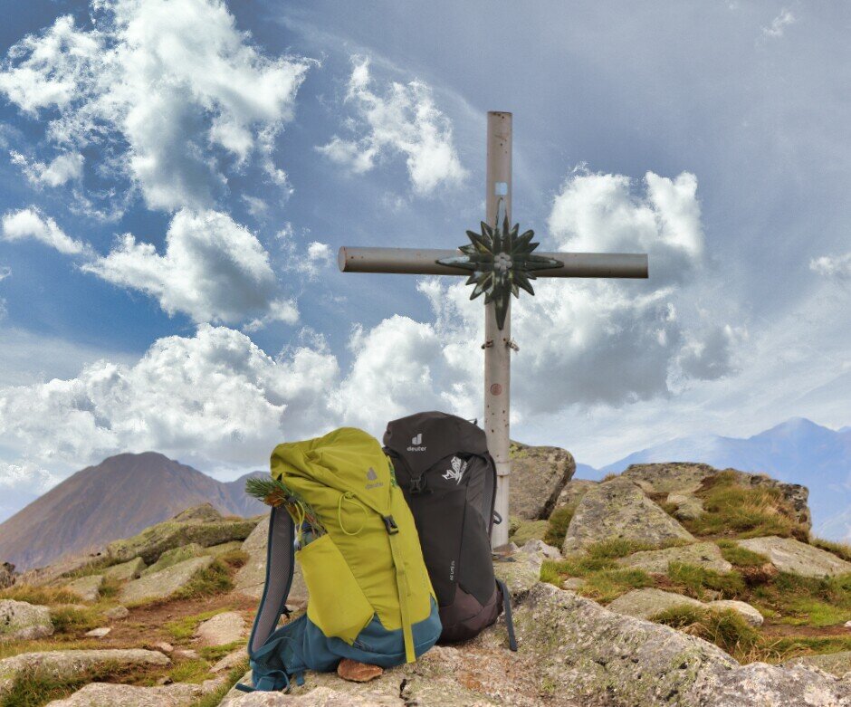
(c)Weges (3).jpg | © Weges | Weges
1/14

Gamskogel_Westgipfeö_Pölstal_Murtal-Steiermark c Martin Muhrer_BergfexMartin (6).jpg | © Martin Muhrer / bergfexmartin.at | Martin Muhrer / bergfexmartin.at
2/14

Gamskogel_Westgipfeö_Pölstal_Murtal-Steiermark c Martin Muhrer_BergfexMartin (2).jpg | © Martin Muhrer / bergfexmartin.at | Martin Muhrer / bergfexmartin.at
3/14

Gamskogel_Westgipfeö_Pölstal_Murtal-Steiermark c Martin Muhrer_BergfexMartin (3).jpg | © Martin Muhrer / bergfexmartin.at | Martin Muhrer / bergfexmartin.at
4/14
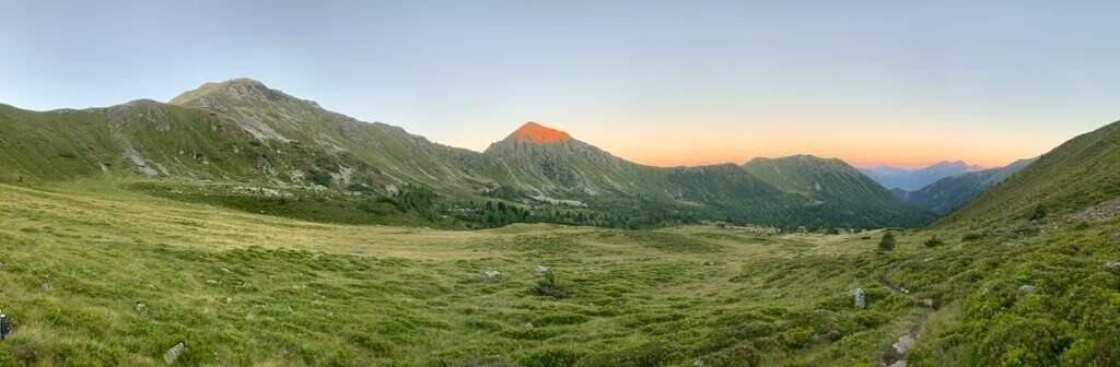
Blick zum Gaalertörl | © Stephan Kandler | Stephan Kandler
5/14

Gamskogel_Westgipfeö_Pölstal_Murtal-Steiermark c Martin Muhrer_BergfexMartin (5).jpg | © Martin Muhrer / bergfexmartin.at | Martin Muhrer / bergfexmartin.at
6/14
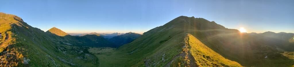
Ausblick vom Gaalertörl zum Gamskogel | © Stephan Kandler | Stephan Kandler
7/14

Gamskogel_Westgipfeö_Pölstal_Murtal-Steiermark c Martin Muhrer_BergfexMartin (4).jpg | © Martin Muhrer / bergfexmartin.at | Martin Muhrer / bergfexmartin.at
8/14
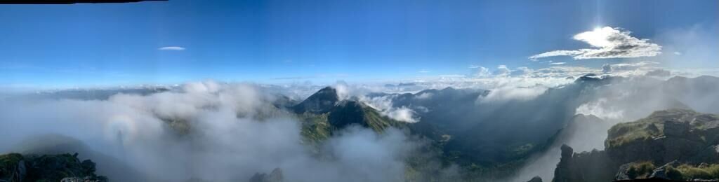
Ausblick vom Gamskogel | © Stephan Kandler | Stephan Kandler
9/14

Gamskogel_Westgipfeö_Pölstal_Murtal-Steiermark c Martin Muhrer_BergfexMartin (7).jpg | © Martin Muhrer / bergfexmartin.at | Martin Muhrer / bergfexmartin.at
10/14

Gamskogel_Westgipfeö_Pölstal_Murtal-Steiermark c Martin Muhrer_BergfexMartin (8).jpg | © Martin Muhrer / bergfexmartin.at | Martin Muhrer / bergfexmartin.at
11/14

Gamskogel_Westgipfeö_Pölstal_Murtal-Steiermark c Martin Muhrer_BergfexMartin (9).jpg | © Martin Muhrer / bergfexmartin.at | Martin Muhrer / bergfexmartin.at
12/14

Gamskogel_Westgipfeö_Pölstal_Murtal-Steiermark c Martin Muhrer_BergfexMartin (10).jpg | © Martin Muhrer / bergfexmartin.at | Martin Muhrer / bergfexmartin.at
13/14

Gamskogel_Westgipfeö_Pölstal_Murtal-Steiermark c Martin Muhrer_BergfexMartin (1).jpg | © Martin Muhrer / bergfexmartin.at | Martin Muhrer / bergfexmartin.at
14/14

What the weather will be like Pölstal (918m)
Today, 30.09.2026
Early clouds will clear to leave the region with a dry and sunny day.Morning

6°C
sr.Regenwahrscheinlichkeit
0%
sr.Windstärke
5 km/h
Noon

19°C
sr.Regenwahrscheinlichkeit
0%
sr.Windstärke
5 km/h
Night

11°C
sr.Regenwahrscheinlichkeit
0%
sr.Windstärke
0 km/h
Tomorrow, 01.10.2026
Dry and bright with plenty of sunshine, clouds will be rare.Morning
6°C
sr.Regenwahrscheinlichkeit
0%
sr.Windstärke
0 km/h
Noon
19°C
sr.Regenwahrscheinlichkeit
0%
sr.Windstärke
5 km/h
Night
11°C
sr.Regenwahrscheinlichkeit
0%
sr.Windstärke
0 km/h
Forecast
02.10.2026
5°C
20°C
03.10.2026
5°C
20°C
04.10.2026
5°C
20°C
