


Skitour to the Grabnerstein
Accessible by public transport- Public bus (within 15 minutes walking distance from starting point)
The tour in numbers
Level of difficulty
medium
Route
14,0 km
Time
3:00 h
Uphill
974 hm
Downhill
974 hm
Highest point
1841 m
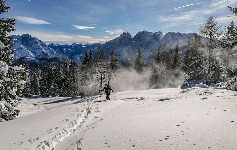
Sunny skitour with a view!
The sun is a constant companion on this ski tour: From the Grabneralm, you continue to the saddle between Grabnerstein and Zilmkogel. From there, you go around the summit slope on the right, then enjoy the descent from the top of Grabnerstein.
Best season
January
February
March
April
May
June
July
August
September
October
November
December
More information
A9 Phyrn motorway to exit Ardning/Admont and from there past Frauenberg, approx. 10 km after Admont. At the roundabout on the left side of the river Enns take the 3rd exit onto the Buchauer Bundesstraße B117 towards Weng and follow this road for about 5 km until you reach the Buchauer Saddle
Parking Buchauer Sattel (paid)
A parking lot with information boards is located directly at the Buchauer Saddle on the left side of the road (coming from Admont).
Or via Leoben, Vordernberg and Eisenerz to Hieflau and from there via B146 in western direction through the Gesäuse to Admont. After the north-south main road through the village, take the 2nd exit at the roundabout in the direction of Weng and follow this road (B117) for about 5 km until you reach the Buchauer Saddle.
A1 Westautobahn to exit Ybbs and from there in southern direction through Scheibbs, Lunz am See, Göstling an der Ybbs and Palfau to Hieflau. From there via B146 in western direction through the Gesäuse to Admont. After the north-south main road through the village, take the 2nd exit at the roundabout in the direction of Weng and follow this road (B117) for about 5 km, you will find yourself on the Buchauer Saddle
Parking Buchauer Sattel (paid)
A parking lot with information boards is located directly at the Buchauer Saddle on the left side of the road (coming from Admont).
Certain passages are steep and require the use of hairpin bends. And despite the low altitude and the route through the forest, it is imperative that you observe the avalanche warning levels!
Emergency call mountain rescue: 140
Safety in alpine terrain
The usual dangers of the mountains - falling rocks, weather-related falls, danger of falling - are exacerbated in winter above all by the danger of avalanches. This poses a challenge for beginners and professionals alike. Being able to assess the avalanche situation requires thorough preparation and years of experience. Therefore, please observe the principles of safe touring. Indispensable are in any case:
Good tour planning (route, avalanche situation report, weather report, weather stations).
Complete equipment
Stay on the route
Minimising the risk
Respect for the rules of nature conservation and thus protect the sensitive nature in the Gesäuse National Park!
Ski touring and avalanche equipment, as well as a ski touring backpack with appropriate contents (water bottle, hiking map, snack, etc.). You should also be well prepared for a change in the weather.Certain passages are steep and require the use of hairpin bends. And despite the low altitude and the route through the forest, it is imperative that you observe the avalanche warning levels!
Grouse like the capercaillie, the black grouse, and the ptarmigan have feathered
toes: this increases their surface area and prevents them from sinking into the
snow - like snowshoes.
To conserve energy, these birds don't take any unnecessary steps in winter – when
it gets particularly cold, they dig themselves a small burrow in the snow. Disturbing
them is like pulling the covers off their beds: they fly up and usually spend the
rest of the day without any protection from the cold.
Therefore, please stay away from wildlife sanctuaries and let the grouse hibernate
peacefully in their "igloos"!
www.oebb.at
www.busbahnbim.at
With the Verbundlinie BusBahnBim app, finding timetable information has never been easier: all bus, train, and tram connections in Austria can be searched for by entering locations and/or addresses, stops, or important points. The app is available as a free app for smartphones (Android, iOS) on Google Play and in the App Store.
In the Gesäuse you are mobile in summer even without your own car. One call to t: +43 3613 2100099 is all it takes: During operating hours, the Gesäuse shared taxi will take you to any destination in the Gesäuse - without any timetable or stops. www.gesaeuse.at/mobil
Tourismusverband Gesäuse
Hauptstraße 35, 8911 Admont, Österreich
Tel. +43 (0) 3613 21160-10
Email: info@gesaeuse.at
www.gesaeuse.at
Map & downloads
Gallery
skitour_grabnerstein_c-christian_scheucher_tvgesaeuse_2.jpg | Christian Scheucher
1/3
schneeschuhwandern_2c-christoph_lukas.jpg | © Christoph Lukas | Christoph Lukas
2/3
hochtor.jpg | © Herb WOLGER | Herbert Wölger
3/3

What the weather will be like Admont (635m)
Today, 15.10.2026
Early clouds will clear to leave the region with a dry and sunny day.Morning

7°C
sr.Regenwahrscheinlichkeit
0%
sr.Windstärke
0 km/h
Noon

16°C
sr.Regenwahrscheinlichkeit
0%
sr.Windstärke
5 km/h
Night

9°C
sr.Regenwahrscheinlichkeit
0%
sr.Windstärke
5 km/h
Tomorrow, 16.10.2026
Some clouds in the morning, lateron much sunshine and hardly any cloudsMorning
6°C
sr.Regenwahrscheinlichkeit
0%
sr.Windstärke
0 km/h
Noon
16°C
sr.Regenwahrscheinlichkeit
0%
sr.Windstärke
0 km/h
Night
8°C
sr.Regenwahrscheinlichkeit
0%
sr.Windstärke
0 km/h
Forecast
17.10.2026
4°C
17°C
18.10.2026
7°C
17°C
19.10.2026
5°C
18°C
