


Bussi Baba Gravel and MTB Tour – Total Tour
Accessible by public transport- Train (within 15 minutes walking distance from starting point)
Characteristics
SkillThe tour in numbers
Level of difficulty
challenging
Route
160,2 km
Time
15:00 h
Uphill
2002 hm
Downhill
2001 hm
Highest point
1102 m
Say “Bussi Baba” to the daily grind and ride through the Gesäuse!
All information here.
All information here.
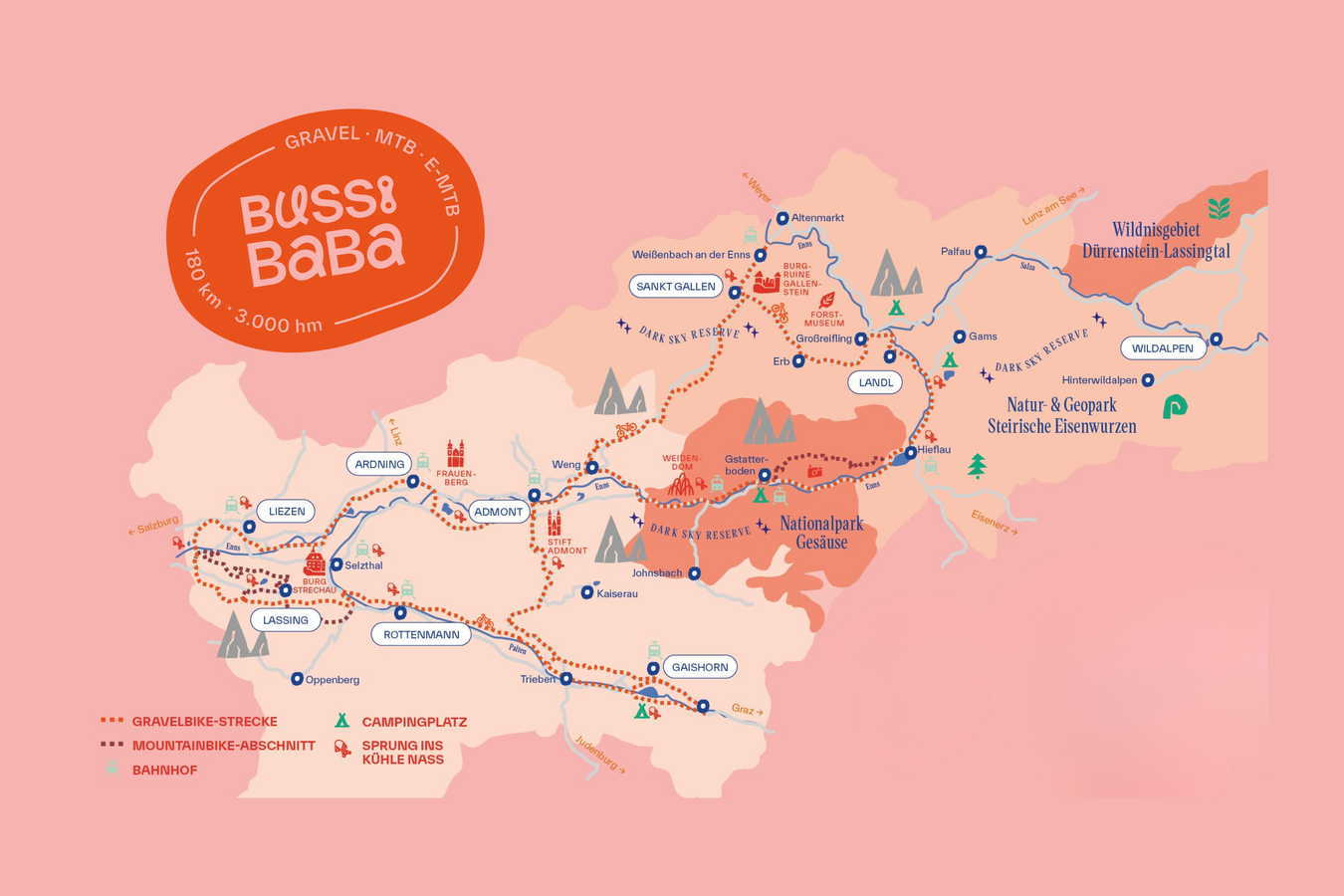
Whether on a gravel bike, MTB, or e-MTB, this route covers about 180 kilometers with up to 3,000 meters of elevation gain through forests, along waterways, up mountains, and past cultural sites—perfect for 1, 2, or 3 days! The main route is ideal for gravel bikes. The mountain bike loops add extra variety to the tour. While some riders tackle a few extra meters of elevation gain, others continue at a more leisurely pace. And later, you’ll simply meet up again along the route.
Best season
January
February
March
April
May
June
July
August
September
October
November
December
More information
The Bussi Baba route is located in the heart of Austria, in the Gesäuse adventure region.
Free parking for several days is available in the respective municipalities.
Free parking for several days is available in the respective municipalities.
Important information before you set off!
The tour is NOT signposted. Make sure you follow the GPX track! The route uses existing cycle paths and optional mountain bike trails, taking you alongside rivers, across panoramic mountains and through rushing valleys.
Depending on your bike and your mood, you decide whether you want to clock up the miles on the gravel route or tackle one or two mountainous mountain bike sections on knobbly tyres.
The mountain bike sections are mostly rated around technical level S1, with short sections at S2. This means you can easily push your gravel bike for a few short stretches and still choose the mountainous mountain bike option.
You will cycle through two road tunnels in the Gesäuse! Remember to bring bike lights!
The route in detail
The best way to start your adventure is from one of the many railway stations along the route. This description therefore begins at the easternmost entry point: Weißenbach-St. Gallen railway station.
From the station, head south and follow the Enns Cycle Path R7 through Weißenbach an der Enns to the centre of the market town of Sankt Gallen. Here, the R7 runs along the B117. You will already catch your first glimpse of the impressive Buchstein and its 2,224-metre summit.
After the town centre, keep slightly left and join the Alte Erbstraße, which runs parallel to the main road but considerably lower down. The route begins to climb gradually along the section known as the Bodenweg.
After passing several fishponds, the route briefly joins the main road. You share the road with motor vehicles for 200 metres before turning left again towards Griesbach and following the signs for the Buchsteinrunde in the opposite direction.
Over the next 6.5 kilometres, you will pedal your way up around 300 metres in elevation towards the Buchauer Sattel. Shortly before the “Lahnalm” car park, you join the road again – watch out for mixed traffic – and follow the main road for another 2.5 kilometres.
At the “Tonnerhof”, a few hundred metres before the highest point, turn right and follow the farm track running parallel to the main road towards the Buchauer Sattel and the Buchauer car park. Refreshments are already waiting for you in the drinks fridge – your reward for completing the climb!
You now roll downhill via the Kletzenberg on a quiet road towards Weng, a village belonging to Admont. A panoramic view of the Hochtor Group and the Reichenstein Massif opens up in front of you. Get off your bike, take it all in and perhaps even snap a photo!
From the peaceful village of Weng, the well-developed R7 cycle path takes you past moorland and fields towards Admont. Early birds may encounter all kinds of wildlife here: deer, foxes, grey herons, common buzzards, jays, woodpeckers … quite a lot of traffic!
You will pass through Admont, which has a railway station, twice during your Bussi Baba Tour! Depending on how you plan your stages, Admont Abbey and the world’s largest monastic library await you here – a genuine cultural highlight.
From Admont, the route continues consistently westwards along the R7 cycle path. You pass through farmland and small settlements before crossing the River Enns. With enough power left in your legs, you can make a detour to the Frauenberg pilgrimage church. It is hard to say which is more impressive: the magnificent church interior or the view of the Hallermauern mountains.
With or without the detour, the R7 continues into the charming and highly liveable municipality of Ardning, which has a railway station, and onwards towards the district capital of Liezen, also served by rail.
Important: Just after an idyllic bridge across the Enns, you will pass an inconspicuous cycle-path junction. The R7 takes you towards Liezen. Alternatively, you can take a shortcut along the R15 Rastland Cycle Path towards Selzthal and its busy railway station.
Whatever you might be missing on your tour, you will probably find it in Liezen! After passing the City Rock climbing centre, the R7 leads you back out of town, through wide meadows and with magnificent views of the free-standing Grimming mountain.
Unless you fancy cooling off in the Weißenbach swimming pond, continue towards Lassing. At the westernmost point of the route, leave the R7 and join the L740 regional road for a few metres – TURN RIGHT – before crossing it and following the R42 cycle path.
Unless you choose the mountain bike option. In that case, KEEP LEFT when joining the regional road.
The mountain bike alternative follows an S-shaped route across the Mitterberg towards Lassing and includes a visit to Strechau Castle. See the detailed description of the Mitterberg MTB Tour.
Follow the R42 cycle path for just 450 metres, then turn sharply right, cross the regional road and cycle uphill towards Stein.
“Things get steep in Stein” could be the slogan for the next few metres. You will have to work hard for the views along this section.
At the small cluster of houses known as “Stein”, keep left and leave the paved road. A short but very steep forest section follows. There is no shame in pushing here – the climb is worth it! Once you reach the top, your well-earned breather comes with a magnificent view of Lassing and the surrounding mountains.
You now cycle along idyllic farm tracks and quiet side roads towards Lassing. Shortly before the village centre, at the cluster of houses called “Wieden”, you meet the alternative mountain bike route – the Mitterberg MTB Tour.
During a well-deserved espresso break in Lassing, you can discuss your next move: Follow the gravel route, join the R42 in Neulassing and speed downhill, or head for Strechau Castle.
The Mitterberg MTB Tour continues towards the castle before following S1 trails downhill into the district of Strechau and returning alongside the River Palten to the Lassing road junction.
From this distinctive junction onwards, follow the R15 Rastland Cycle Path.
The pleasant cycle path takes you to Versbichl, through Villmannsdorf and onwards to Rottenmann without any significant climbs. A detour into the town centre is well worth it. Pretty façades on old craftspeople’s houses, impressive church towers and numerous hidden sights await you in the medieval town of Rottenmann, which also has a railway station.
Continue through the districts of Büschenkopf and Bärnkopf, cross a motorway bridge and head towards Trieben. Here, too, you will find plenty of shops directly along the route, making it easy to stock up for the kilometres ahead.
Before long, you head back towards the sunny southern slope on the opposite side of the valley and cycle through Gaishorn, which has a railway station, towards Lake Gaishorn. This idyllic natural area, home to numerous swans and other lakeside residents, sweetens the kilometres alongside the River Palten as far as Treglwang.
Treglwang marks the southernmost point of the Bussi Baba Tour. It is an ideal place to spend the night before tackling the Kaiserau with fresh legs the following morning.
First, however, you cycle back to Gaishorn along a pleasantly shady section. From Gaishorn, the next four kilometres may look familiar: They return you to the junction and the beginning of the climb towards the Kaiserau.
Caution: There is NO cycle path here. You share the road with motor traffic!
The road initially climbs gently through Dietmannsdorf before becoming steeper. Around 400 metres of elevation over seven kilometres await you – complete with that mountain-pass feeling!
A popular viewpoint with a small chapel invites you to stop for a photo around two kilometres below the highest point. What a welcome excuse to catch your breath.
Now for the final uphill sprint. Between the tall forests of the Kaiserau, the mountain peaks slowly begin to appear. The view of the Reichenstein Group soon makes you forget the effort of the climb.
Once you reach the highest point by the car park and pond, a short, flat detour of around three kilometres in total takes you right into the heart of the high plateau and to the “Sportalm”. It is difficult to imagine a more idyllic place to enjoy a slice of strudel!
Now it is time to head downhill! The road winds attractively through partly narrow bends for six kilometres. What a relief!
From the district of Kematen onwards, the road becomes flatter again before rejoining the Enns Cycle Path R7 directly in Admont.
Follow the signs through Admont, which has a railway station, and continue through the Eichelau towards the open countryside.
Do you remember these five kilometres? Earlier, you sped downhill from the Kletzenberg into Weng. This time, however, stay in the valley and follow the Enns Cycle Path into the Gesäuse.
The old Gesäuse road is gently undulating. Before long, the cycle path is no longer physically separated and continues ON THE ROAD – watch out for motor traffic!
One of the many magnificent views into the entrance of the Gesäuse awaits you from the Lauferbauer Bridge, a rare wooden bridge.
You are now approaching the entrance to the Gesäuse, a narrow section of the River Enns where the roaring water gave its name to an entire mountain range – and indeed to an entire region.
Welcome to Gesäuse National Park!
Caution: Until you reach the Johnsbach junction, you will be sharing the road with motor traffic!
Immediately after the junction, turn left towards Johnsbach railway station. You can now enjoy the Rauchbodenweg, a gravel track leading to Gstatterboden and offering spectacular views of the River Enns.
At the Gstatterboden railway crossing, it is time to make another decision.
The gravel route crosses back over the Enns bridge and immediately turns left onto the Ennsbodenweg. For the next three kilometres, the route follows the River Enns without any significant climbs. Here, the roaring river gradually transforms into calm water above the power station’s dam.
The mountain bike option continues straight ahead in the same direction. After passing the National Park Pavilion, the mountain bike tour climbs to the “Hochscheiben” and rejoins the gravel route in Hieflau. See the detailed description of the Hochscheiben MTB Tour.
After the Enns power station, the R7 has no alternative but to join the road – watch out for mixed traffic! For your own safety, make sure you use the short, physically separated cycle-path sections and the multipurpose lanes on the road.
A few kilometres before Hieflau, you will pass through two tunnels. Switch on your lights whenever possible!
Once you reach Hieflau, a few punchy metres of climbing await you before you enter the gentle landscape at the edge of the Gesäuse Massif.
Follow the so-called Eisenstraße, the B115, to the Mooslandl junction. From there, a cycle path leads through Kirchlandl and onwards to Großreifling.
At a 180-degree bend, leave the B117 and follow the idyllic Erbstraße, the L705, towards Sankt Gallen. With a moderate gradient of four to five per cent, little traffic, the rushing Mühlbach stream and shady forests, the climb to the Hocherb is a true pleasure.
And it gets even better: Once you reach the Erbsattel, Kassegg Castle is waiting just a few metres off the route. It is an excellent Bed+Bike accommodation with a café, restaurant and cosy beds. A warm welcome is guaranteed!
You can now fill your belly to your heart’s content because from here onwards, it is downhill all the way!
The spacious road leads swiftly down to Sankt Gallen. Shortly before a barely noticeable counter-climb, the ruins of Gallenstein Castle appear on your right.
Those who fancy it can turn right, follow the signs towards the castle and pedal all the way into the courtyard. Those who already have enough elevation in their legs can simply enjoy the relaxed ride across the pretty market square before rolling downhill to Weißenbach-St. Gallen railway station – a familiar sight if this is where you started your tour.
Depending on your bike and what you’re in the mood for, you can decide whether you want to
cruise down the gravel route or tackle one or two mountainous mountain bike trails.
The mountain bike sections are generally rated around S1 in terms of technical difficulty, with short sections at S2. This means you could easily gravel bike easily on short stretches and still choose the mountainous mountain bike route.
You’ll ride your bike through two road tunnels in the Gesäuse!
Don’t forget a bike light!
Trails are open from April 15 to October 31. Please observe trail closures and take them seriously.
cruise down the gravel route or tackle one or two mountainous mountain bike trails.
The mountain bike sections are generally rated around S1 in terms of technical difficulty, with short sections at S2. This means you could easily gravel bike easily on short stretches and still choose the mountainous mountain bike route.
You’ll ride your bike through two road tunnels in the Gesäuse!
Don’t forget a bike light!
Trails are open from April 15 to October 31. Please observe trail closures and take them seriously.
Travel comfortably by public transit!
There are numerous train stations along the route that will take you to the Gesäuse and back.
Simply check your connection and select “Bike Transport”: ÖBB Scotty Timetable Information
ÖBB Opening Hours and Alternatives
The entire route is open from April 15 to October 31 and is subject to the opening hours of the mountain bike trails. If you’d still like to ride through the Gesäuse outside of this period, you can bypass the mountain bike sections by taking public roads. This route is also suitable for road bikes and is paved throughout. Lassing: From the R7 state bike path, take the road to Lassing for a short distance, then merge onto the R42 and R15. Instead of the Hochscheiben MTB route: Gesäuse Federal Highway (mixed traffic throughout!) Buchau or Buchauer Sattel: Federal Highway (mixed traffic throughout!)
There are a total of 10 train stations along the Bussi Baba route: Ardning, Selzthal, Liezen, Rottenmann, Gaishorn, Admont, Johnsbach, Gstatterboden, Hieflau, and Weißenbach near Sankt Gallen. This means you can easily travel to the Gesäuse by train and bike from any direction.
www.oebb.at
Click on “www.busbahnbim.at” and then “Bike Transport”!
www.oebb.at
Click on “www.busbahnbim.at” and then “Bike Transport”!
Cyclist-friendly lodging providers are looking forward to welcoming you!
Bussi-Baba Gravel Tour
For more information and current road closures, contact
Gesäuse Tourism Association,
Hauptstraße 35,
8911 Admont, Austria
t: +43 3613 211 60 10
info@gesaeuse.at
www.gesaeuse.at
Bussi-Baba Gravel Tour
For more information and current road closures, contact
Gesäuse Tourism Association,
Hauptstraße 35,
8911 Admont, Austria
t: +43 3613 211 60 10
info@gesaeuse.at
www.gesaeuse.at
Map & downloads
Gallery
bussi-baba_karte_1.png | Tourismusverband Gesäuse
1/2
transnationalpark_c-thomas_sattler_1722186173.jpg | thomas sattler
2/2

What the weather will be like Ardning (664m)
Today, 15.10.2026
Early clouds will clear to leave the region with a dry and sunny day.Morning

6°C
sr.Regenwahrscheinlichkeit
5%
sr.Windstärke
0 km/h
Noon

16°C
sr.Regenwahrscheinlichkeit
0%
sr.Windstärke
5 km/h
Night

9°C
sr.Regenwahrscheinlichkeit
0%
sr.Windstärke
0 km/h
Tomorrow, 16.10.2026
Dry and sunny throughout the day with hardly any clouds.Morning
4°C
sr.Regenwahrscheinlichkeit
0%
sr.Windstärke
0 km/h
Noon
16°C
sr.Regenwahrscheinlichkeit
0%
sr.Windstärke
0 km/h
Night
8°C
sr.Regenwahrscheinlichkeit
0%
sr.Windstärke
0 km/h
Forecast
17.10.2026
3°C
16°C
18.10.2026
6°C
16°C
19.10.2026
5°C
17°C
