


Hike to Englitztal Valley
Characteristics
SkillThe tour in numbers
Level of difficulty
easy
Route
5,8 km
Time
2:30 h
Uphill
340 hm
Downhill
340 hm
Highest point
1320 m
From Öblarn, a long valley known as the Walchental leads into the area of the former copper mining site “In der Walchen.”
The journey into the upper Walchental is already an experience in itself. A narrow road runs alongside the stream, framed by steep, forested slopes, leading into the former mining area known as “In der Walchen” and further on to the two alpine valleys.
This is also where the Öblarn Copper Trail is located, offering fascinating insights when explored as part of a guided tour.
This is also where the Öblarn Copper Trail is located, offering fascinating insights when explored as part of a guided tour.
Best season
January
February
March
April
May
June
July
August
September
October
November
December
More information
From the A10: At Altenmarkt (Exit 63), turn toward Graz. Follow the B99 to Radstadt. From there, take the B320 toward Graz. At Pruggern, follow the sign for Öblarn.
From the A9: At Selzthal (Exit 69), turn toward Liezen/Radstadt. From Liezen, take the B320 to Espang. There, turn toward Öblarn.
For the hike: From the center of Öblarn, head toward Walchen (swimming pool). The Walchen Valley is a dead-end valley. From the swimming pool, it’s about 6 km to the parking lot at the ÖAV mountain hut.
Mountain Lodge in Walchen
From the A9: At Selzthal (Exit 69), turn toward Liezen/Radstadt. From Liezen, take the B320 to Espang. There, turn toward Öblarn.
For the hike: From the center of Öblarn, head toward Walchen (swimming pool). The Walchen Valley is a dead-end valley. From the swimming pool, it’s about 6 km to the parking lot at the ÖAV mountain hut.
Mountain Lodge in Walchen
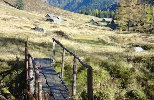
At the crossroads after the ÖAV mountain lodge, turn right off the forest road. A small bridge leads you onto a narrow forest path that climbs up to a wider alpine track. From there, continue at a moderate incline, passing the “White Wall” – a former marble quarry – and follow the trail through several switchbacks until the wide, open valley floor of the Englitztal suddenly unfolds before you.
The Englitztal valley reveals a picturesque alpine landscape at 1,328 m, with a small stream, lush meadows and scattered ancient larch trees. Surrounded by steep wooded slopes, the valley is closed off to the north by the striking rock formation of the Hangofen peak. Shortly afterwards, you reach the welcoming Englitztal hut. The area is ideal for families, with the stream providing a natural playground and the flat terrain perfect for a relaxed alpine walk.
The Englitztal valley reveals a picturesque alpine landscape at 1,328 m, with a small stream, lush meadows and scattered ancient larch trees. Surrounded by steep wooded slopes, the valley is closed off to the north by the striking rock formation of the Hangofen peak. Shortly afterwards, you reach the welcoming Englitztal hut. The area is ideal for families, with the stream providing a natural playground and the flat terrain perfect for a relaxed alpine walk.
In September in particular, please pay attention to the signs regarding hunting and the associated restrictions on hiking.
Weather changes, rapid drop in temperature, thunderstorms, wind, fog and snow fields are objective dangers and require the right behavior on the way. Hut keepers are experienced mountain connoisseurs, they can give good tips on the weather and the course of the trail. Lack of equipment, overestimation of one's own abilities, carelessness, poor physical condition and a wrong assessment can lead to critical situations. During thunderstorms: avoid peaks, ridges and rope belays at all costs.
GPS data and orientation aids: Available GPS data - as well as hiking maps - are only an orientation aid, since they can never represent an exact image or the richness of detail of a path in reality. Especially in the case of danger spots, it must therefore always be decided in the end on the basis of the conditions on site whether and how the further course of the path looks like.
In case of emergency, please dial the following emergency numbers:
No. 140 - for alpine emergencies - Austria-wide
No. 112 - Euro emergency call GSM emergency call service
Take rainproof and warm clothes and enough water, possibly also a snack, wear shoes with non-slip profile soles. A first aid kit should also be in your backpack.
Weather changes, rapid drop in temperature, thunderstorms, wind, fog and snow fields are objective dangers and require the right behavior on the way. Hut keepers are experienced mountain connoisseurs, they can give good tips on the weather and the course of the trail. Lack of equipment, overestimation of one's own abilities, carelessness, poor physical condition and a wrong assessment can lead to critical situations. During thunderstorms: avoid peaks, ridges and rope belays at all costs.
GPS data and orientation aids: Available GPS data - as well as hiking maps - are only an orientation aid, since they can never represent an exact image or the richness of detail of a path in reality. Especially in the case of danger spots, it must therefore always be decided in the end on the basis of the conditions on site whether and how the further course of the path looks like.
In case of emergency, please dial the following emergency numbers:
No. 140 - for alpine emergencies - Austria-wide
No. 112 - Euro emergency call GSM emergency call service
Take rainproof and warm clothes and enough water, possibly also a snack, wear shoes with non-slip profile soles. A first aid kit should also be in your backpack.
SummitLynx- Your digital summit and hut book - available worldwide and always with you!
For more information, please contact the Schladming Dachstein Tourist Office:
Phone: +43 3687 23310
mailto:info@schladming-dachstein.at
The brochure “Schladming-Dachstein Hiking” is available in all information offices in the region.
Phone: +43 3687 23310
mailto:info@schladming-dachstein.at
The brochure “Schladming-Dachstein Hiking” is available in all information offices in the region.
Map & downloads
Gallery
Englitztal | © Erlebnisregion Schladming-Dachstein
1/1

What the weather will be like Öblarn (668m)
Today, 24.09.2026
Fair in the early morning, then considerable cloudiness and frequent rain.Morning

9°C
sr.Regenwahrscheinlichkeit
0%
sr.Windstärke
5 km/h
Noon

14°C
sr.Regenwahrscheinlichkeit
80%
sr.Windstärke
10 km/h
Night

10°C
sr.Regenwahrscheinlichkeit
85%
sr.Windstärke
5 km/h
Tomorrow, 25.09.2026
Early clouds will clear to leave the region with a dry and sunny day.Morning
6°C
sr.Regenwahrscheinlichkeit
10%
sr.Windstärke
5 km/h
Noon

17°C
sr.Regenwahrscheinlichkeit
0%
sr.Windstärke
5 km/h
Night

11°C
sr.Regenwahrscheinlichkeit
0%
sr.Windstärke
0 km/h
Forecast
26.09.2026
4°C
21°C
27.09.2026
4°C
22°C
28.09.2026
6°C
24°C
